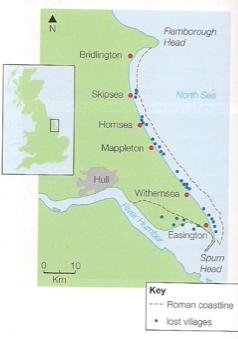
Holderness
Erosion
The Holderness Coast is one of Europe’s fastest eroding coastlines. The average annual rate of erosion is around 2 metres per year. The main reason for this is because the bedrock is made up of till (soft clay). This material was deposited by glaciers around 12,000 years ago.
The coastline stretches along the coast of the East Riding of Yorkshire, known as Holderness, from Flamborough Head in the North, to Spurn Head in the south. Since Roman times, the Holderness Coast has retreated 4 km – at least 29 villages have been lost to the sea.
Why is erosion a problem?
Rates of erosion vary in places due to a mixture of human and physical factors. These can change in short and long term. There are three main reasons why Holderness is retreating:
• Geology (Figure 3)
• Fetch
• Longshore drift and beach material
Geology
The Holderness Coastline is made up of soft boulder clays (tills) left after the retreat of the Devensian ice sheets about 12 000 years ago. They can be seen on the coast, being rapidly eroded by the sea. To look at, they are a mass of brown clay containing pieces of rock (erratics) brought here by the glaciers from Scandinavia, Scotland, the Lake District and Northeast England. These soft, recent deposits sit on a platform of chalk which slopes away gently to the east.
Boulder clay is structurally weak, and has little resistance to erosion. It produces sloping cliffs between 5 and 20metre high. Chalk surrounds the boulder clay. This is a much stronger rock but has eroded along fault lines and bedding planes forming structures like cliffs, caves, arches and stacks. 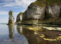
Fetch
This is how far the waves have travelled. Holderness is exposed to wind and waves from the north-east, with a fetch of 500 to 800 km across the North Sea. This is not that far and would normally cause large waves but other factors increase their size:
• Currents (or swell) move northwards around the UK from the Atlantic and into the North Sea. The Atlantic’s fetch is 5000km so it’s currents add even more energy to the waves. This causes powerful destructive waves.
• Weather systems and winter storms in the North Sea are often intense. The low pressure raises the sea level, producing higher tides than normal and the storms add energy to the waves, especially in storms.
• The sea floor is deep in the North Sea, meaning waves hit the coast relatively fast and are not slowed down by friction.
Longshore Drift and Beach Material
• The beaches here are the main problem. Boulder clay erodes very easily and produces very small, fine clay particles, these are easily transported by longshore drift out to sea and along the coast, rather than accumulating in front of the cliffs, forming a layer of protection from the waves. The beaches are narrow and fail to absorb the wave energy, during high tide there is not enough beach and waves hit the base of the cliffs.
• Tides flow to the south, transporting material along the coast. There is an imbalance as the harder chalk up the coast does not provide enough material for places like Hornsea so backwash removes more than what is deposited by swash.
http://www.bbc.co.uk/education/clips/z8jfb9q
Why Manage?
ECONOMIC IMPACTS OF EROSION:
• Numbers of visitors to areas along of this coastline has dropped.
• Some settlements unable to maintain a viable population to warrant shops.
• Money has to be spent on coastal management and protection.
• The Gas Terminal in Easington, which supplies 25% of Britain’s gas, is at risk.
• 80000m2 of farmland is lost each year, this has a huge effect on farmer’s livelihoods.
• It’s predicted that 200 homes and several roads will fall into the sea by 2100 .
SOCIAL IMPACTS OF EROSION:
• Around 30 villages have been lost since Roman times, meaning homes and businesses have been lost.
• Many of the settlements rely heavily on tourism, as facilities close down the settlements are unable to maintain a good population.
• Properties under threat of erosion lose their value leaving owners with negative equity. There is no financial help to aid people as no compensation is paid out for the loss of private property or land caused by coastal erosion in England.
• The East Riding Coastal Fund has been set up to aid people.
ENVIRONMENTAL IMPACTS OF EROSION:
• Wildlife behind Spurn Point is losing diversity as the environment cannot support many species due to the lack of sediment. Spurn Head is a spit and salt marsh at the southern tip of the coastline.
• Some SSSIs (Sites Of Special Scientific Interest) are threatened by erosion.
Management
Coastal Management
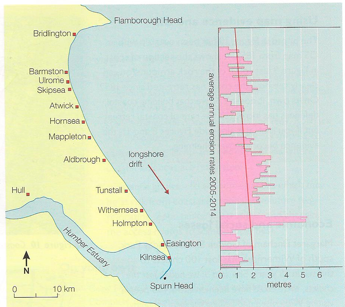
- The graph shows erosion rates opposite to their specific locations. Where there are gaps, it means coastal defences are present and working. You can see that there are higher rates of erosion directly south of these defences.
- This is due to the flow of beach material by longshore drift being stopped by protection methods such as groynes, sea walls and rock armour/rip rap.
- Hornsea may well be protected but places like Mappleton, directly south are starved of material are eroding at excessive rates, this is called terminal groynes syndrome.
- Explain why erosion is such a problem in the Holderness Coastline.
- Your answer should include: Soft rock / clay / till