Plate Boundaries
Map
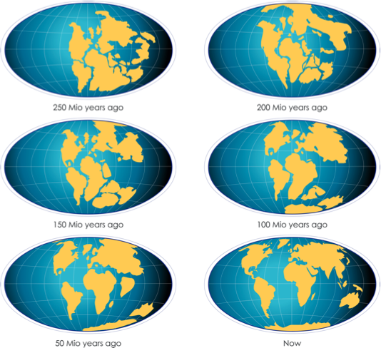
These maps show the theory of continental drift, whereby the earth’s continents move on plates. 250 million years ago, there was one supercontinent called Pangaea.
Types
Today’s the Earth lithosphere is split into a number of different tectonic plates.
Where the two plates meet, there is a plate boundary.

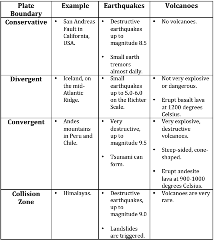
There are 3 different types of plate boundary:
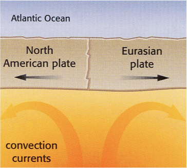
Divergent - formed when two plates move apart.

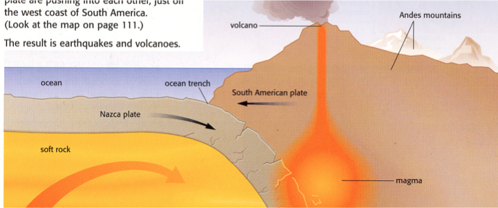
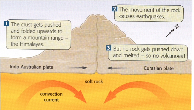
Convergent - formed when two plates collide.
Conservative - formed when two plates slide past each other.

Volcanoes
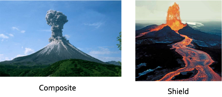
Composite Volcanoes
Composite volcanoes are found on destructive plate margins, where the oceanic crust sinks beneath the continental crust. Composite volcanoes have the following characteristics:
- Acidic lava, which is very viscous (sticky)
- Steep sides as the lava doesn’t flow very far before it solidifies
- Alternate layers of ash and lava. For this reason, they’re also known as stratovolcanoes. Strato means layers
- Violent eruptions
- Longer periods between eruptions
Shield Volcanoes
Shield volcanoes are found on constructive plate margins, where two plates move away from one another. Shield volcanoes have the following characteristics:
- Basic lava, which is non-acidic and very runny
- Gentle sides as the lava flows for long distances before it solidifies
- No layers, as the volcano just consists of lava
- Less violent eruptions
- Shorter periods between eruptions
Lava
Shield volcanoes on land form where basalt is erupted. This often over a hot spot or mantle plume away from plate margins are destructive plate boundaries ie. Hawaii. This forms a gentle sloping volcano. Whereas composite are typical of destructive or subduction zone boundaries. Here sediments and water from the descending plate make the magma high in silica and gas and therefore more viscous and explosive.
Distribution
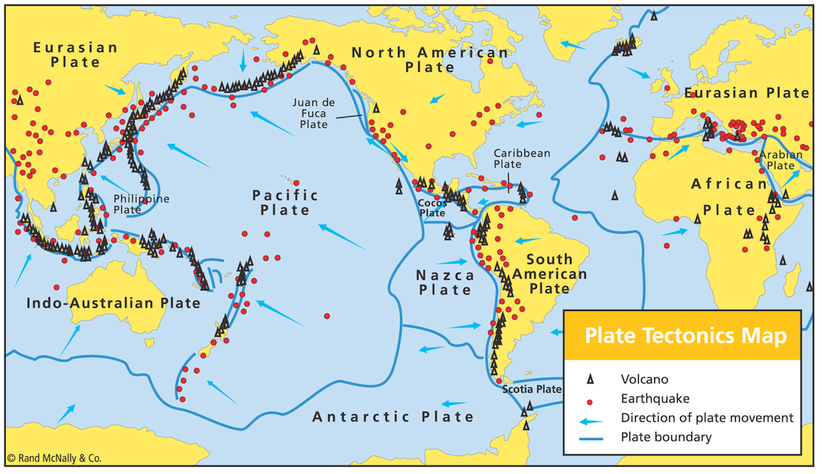
Volcanoes and earthquakes are distributed all over the world in different countries and continents but are not found it every country.
- Found mostly on the coastline
- Especially on tectonic plate boundaries
Volcano prone areas:
- ‘The Ring of Fire’
- Around the Pacific plate.
- Across the North and South Atlantic ocean
- There are still anomalies - Hot spots
Earthquakes:
- Millions of tiny earthquakes happen everyday, but we only manage to notice the bigger, major ones.
- Found on mainland and coastlines
- Especially tectonic plate boundaries
Earthquake prone areas:
- Around Pacific Ocean
- Along the Indo-Australian pate boundary
- Eastern side of Eurasian plate
- Western side of North American plate
- Volcanoes and earthquakes are both found on plate boundaries.
A volcanic hotspot is an area in the mantle from which heat rises from deep in the Earth. High heat and lower pressure at the base of the tectonic plate causes melting of the rock. This melt, called magma, rises through cracks and erupts to form volcanoes. As the tectonic plate moves over the stationary hotspot, the volcanoes are rafted away and new ones form in their place. This results in chains of volcanoes, such as the Hawaiian Islands.
Earthquakes
Earthquakes are the sudden violent shaking of the ground. This happens because the Earth’s plates are constantly moving. Sometimes, because of friction, plates try to move and become stuck. Pressure builds up because the plates are still trying to move. When the pressure is released, it sends out huge amounts of energy causing the Earth’s surface to shake violently.
The point inside the Earth’s crust where the earthquake originates from is known as the focus. The earthquake’s energy is released in seismic waves and they spread out from the focus. The seismic waves are most powerful at the epicentre. The epicentre is the point on the Earth’s surface directly above the focus.
Earthquakes are found at all three plate boundaries: constructive, destructive and conservative plate boundaries.
http://www.bbc.co.uk/education/clips/zb23cdm
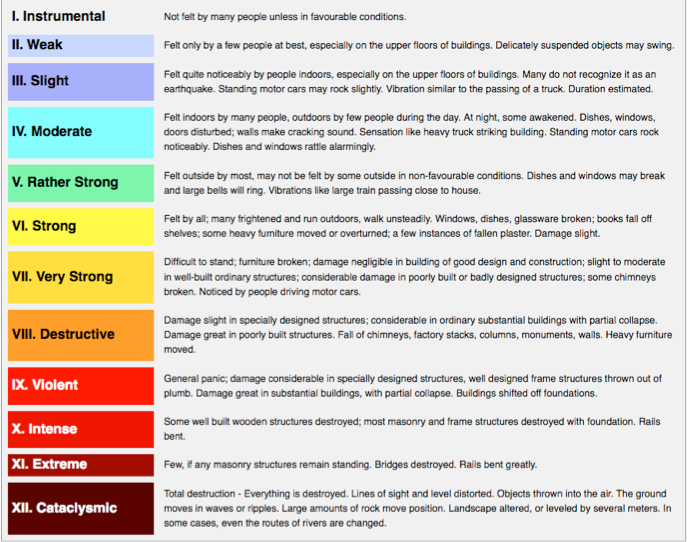
Impact: The effect of an earthquake is the damage which happens as a result of the earthquake. The effects of an earthquake can vary depending on:
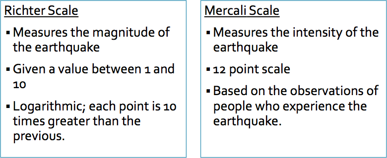
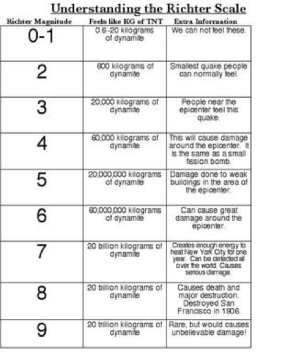
- The size of the earthquake on the Richter scale - the higher it is on the scale, the more destruction it can cause.
- Level of development - whether it occurs in a rich or a poor country. Richer countries will be more likely to be able to predict, protect and prepare themselves from the effects of an earthquake.
- The depth of the focus - if it’s shallow, it can be more destructive.
- Distance from epicentre - the effects of an earthquake are more severe at its centre.
- Population density - the more people living in an area, the more likely that more deaths and casualties may arise.
- The time of day - whether people are in their homes, work or travelling.
We can classify the effects of an earthquake into the following categories:
- Primary effects - things that happen immediately as a result of an earthquake
- Secondary effects - things that happen in the hours, days and weeks after the initial earthquake
Response
Responses are how countries react to an earthquake. They are categorised as follows:
Short-term or immediate - a response in the days and weeks immediately after a disaster has happened. Short-term responses mainly involve search and rescue and helping the injured.
Long-term - responses that go on for months and years after a disaster. It involves rebuilding destroyed houses, schools, hospitals, etc. It also involves kick-starting the local economy.