The Global Atmospheric System
Global Temperature Differences
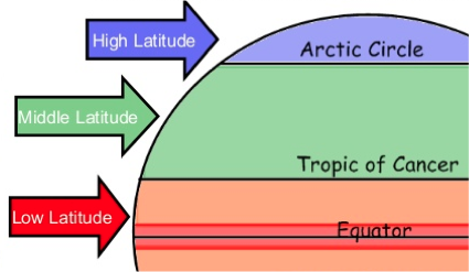
The sun heats up air in the Earth’s atmosphere. The temperature of the Earth’s atmosphere depends on latitude (how far away you are from the Equator). As the Equator is closest to the sun, the air here is warm and the air at the North & South Pole is cold.
Low Latitudes have warm air because it is closest to the sun. High latitudes have cold air because it is far away from the heat of the sun.
The ICTZAnd Africa
It is commonly thought that the sun is overhead at the equator all year round, this however is not true.
Due to the earth spinning on a tilted axis the position of the overhead sun migrates
Northwards, when we have our summer solstice (longest
Southwards, our winter solstice (shortest day).
This means the ITCZ is also going to travel north and south through out the year. This means the heavy rain showers on the West coast of Africa are very seasonal.
The greatest amount of rain falls across the coast of West Africa. Here rainfall can exceed 2000mm per year. The further north you go, the less rain, so in the Sahara desert there is less than 250mm per year.
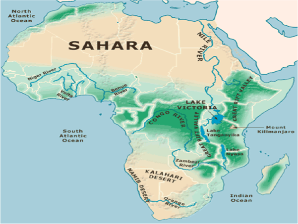
Along the coast, rain falls in every month, because it has an equatorial climate. But just north of the coast there is one month dry season.
The dry season becomes longer the further north you go.
So in Nigeria, it is 9 months and in the Sahara it is 12 months
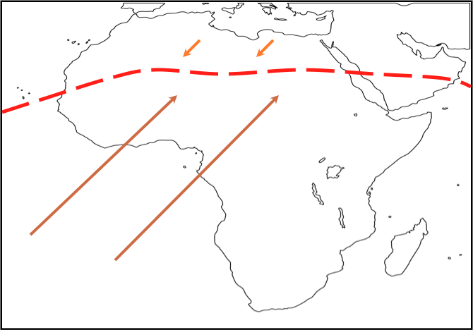
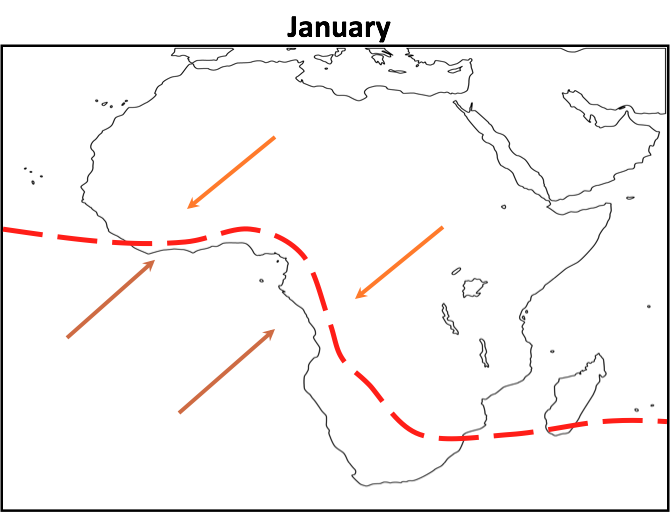
- The SW and NE trade winds blow towards the Equatorial Low Pressure, this is the ITCZ
- The ITCZ moves with the overhead sun, because where the sun is overhead should be the hottest area.
- The ITCZ is over the Tropic of Capricorn in Africa on December 21
- Land heats up a lot quicker than oceans so the ITCZ follows the coast of Africa instead of going into the Atlantic Ocean
- On June 21 the ITCZ is over the Tropic of Cancer
June
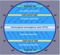
Atmospheric Circulation
Atmospheric circulation is the movement of air around the Earth to try and balance the temperature. This is done in part by the Tri-Cellular Model. Air is different temperatures around the world (because the sun shines most at the equator and less at the poles). This creates areas of either high or low pressure that circulate around the globe.
Air Pressure
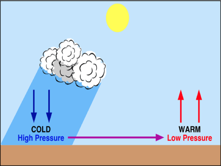
Air pressure is the weight of the air pressing down on the earth’s surface.
As the sun heats the earth this creates warm air. This air is less dense and rises, creating areas of low pressure.
In areas where air is colder, it is more dense and creates areas of high pressure.
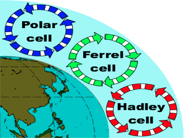
The Tricellular Model
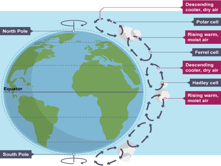
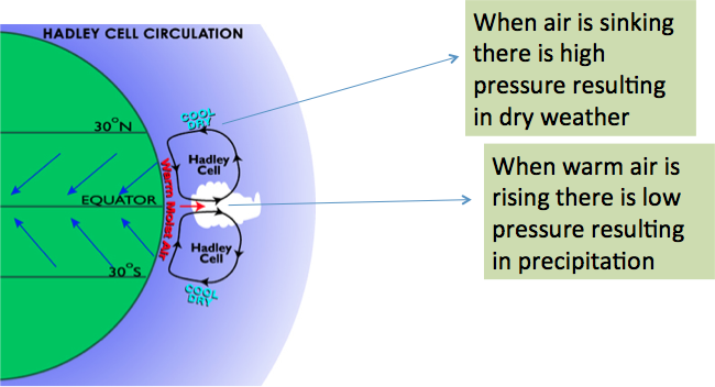
The Hadley Cell
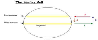
- Sun heats the air and it rises at the equator to create an area of low pressure on the earth’s surface.
- As the air cools it spreads out towards the poles.
- Cool air is dense and therefore sinks back down to earth at about 35 º N and 35 º S of the equator. As it sinks it is pressing down on the earth creating an area of high pressure.
- Air moves from high to low pressure, so air ruches in at ground level to replace the rising air.
The effect of this air sinking or rising creates two pressure belts across the globe.
The point at which the Hadley Cells converge shifts during the year. This is called the INTER TROPICAL CONVERGENCE ZONE (ITCZ) and affects which places get monsoon rains or dry seasons.
The Polar Cell
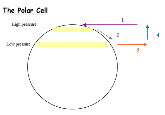
- Dense cold air falls in polar regions creating areas of high pressure.
- It then spreads to lower warmer latitudes.
- As the air rises it expands and becomes lighter and therefore rises.
- As the air rises it cools down again and spreads north and south.
Similar to the Hadley Cell the Polar Cell creates two bands of low and high pressure.
The Ferrel Cell
This is a response to the other two cells. This cell feeds warm air to high latitudes and transfers cold air back to the subtropics for warming.
Winds
Global winds blow from high to low pressure. The earth is constantly rotating and deflects winds to the right in the Northern Hemisphere and to the left in the southern hemisphere. This is called the Coriolis Effect.
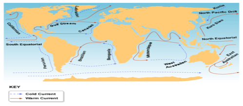
Ocean Currents Heat
Ocean currents are movements of surface water. How the world’s oceans move has a huge influence on our climate as oceans cover 67% of the earth’s surface. Therefore oceans receive 67% of the sun’s energy that reaches earth. Like atmospheric circulation, ocean currents help to redistribute energy across the earth. The worlds oceans hold on to heat from the sun for longer than the land does, and the ocean currents move this heat around, from the tropics (low latitudes) to higher latitudes (The Artic). In total, ocean currents transfer about 25% of the global heat.
The currents set up circular loops or gyres (circular oceanic surface currents) in both the northern and southern hemispheres. The pattern of current flow is clockwise in the northern hemisphere and anti-clockwise in the southern hemisphere
In the Atlantic and Pacific oceans, the currents make a similar pattern
Flowing away from the Equator:
Ocean currents flowing away from the equator are called warm currents - they aren’t necessarily warm, just warmer than water at that latitude. Eg: The Gulf Stream.
Flowing towards the Equator:
If a current flows towards the equator it is a cold current. Eg; Canaries current
How Ocean Currents Work
- The prevailing winds on the surface create friction with the surface water, setting up the ocean currents.
- Ocean currents don’t flow due north or due south because of the coriolis effect caused by the earth’s rotation.
- The coriolis effect deflects the currents to the right in the northern hemisphere and to the left in the southern hemisphere.
- Cold dense polar water sinks, then spreads towards the equator where it pushes up the less dense warmer water which moves off towards the polar areas.
- Where and why would we find different areas of air pressure around the world?
- Your answer should include: Temperature / Sun / Equator
- Explain how heat travels around the earth using the Tri-Celluar Model.
- Your answer should include: Hadley / Ferral / Polar / Cell / Cold / Air / Sinks / Hot / Rises
- Explain how ocean currents can influence climates
- Your answer should include: Gyres / Gulf / Stream / Canaries / Current / Transfer / Store / Heat
Explanation: Explain how ocean currents can influence climates (4 marks) Gyres Gulf Stream Canaries Current Transfer Store Heat