Features in Different Courses
Profiles
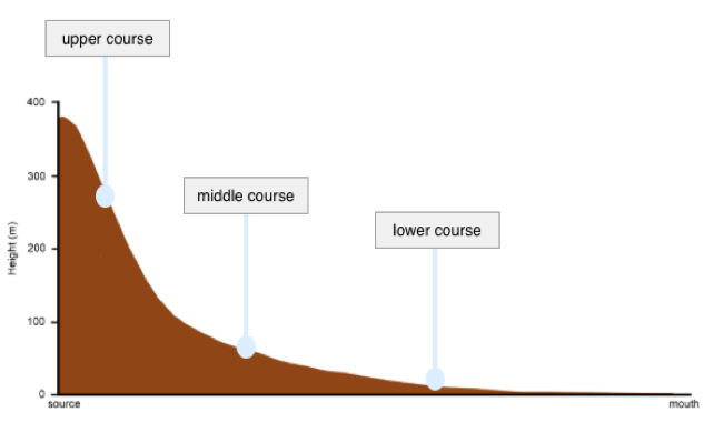
The long profile of a river shows the height and gradient of a river from the source to the mouth.
It shows how the steepness of the river changes.
Long profiles are also used to show the three courses of a river; upper, middle and lower.
The cross profile shows the cross section of a river. It shows the width and depth of the river and river valley. Again, it shows the Upper, Middle and Lower course of the river.
Upper Course

- Steep Gradient
- Narrow Channel
- Lots of energy
- Lots of erosion (vertical)
- Fast (steep)
- Large load
- Steep valley sides (V shape)
Because the gradient is steep and the river erodes vertically it creates a steep valley in a V shape.
As the river erodes it takes the easiest route through soft rock and winds to avoid the harder rock. This forms an interlocking spur.
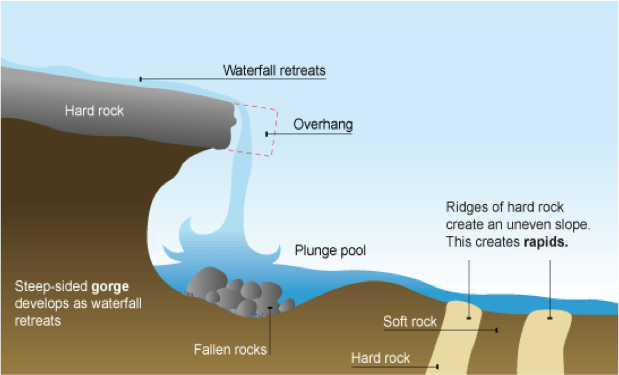
Gorges: As the waterfall retreats backwards (as the process is repeated) it leaves behind a steep sided river channel called a gorge.
Middle Course
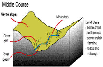
- Less steep gradient
- Wider River Channel
- Less energy (but quite a lot still)
- Quite a lot of erosion (lateral)
- Fast flow
- Smaller load
- Wider Valley
In the Middle Course of a river the most common features are meanders and oxbow lakes.
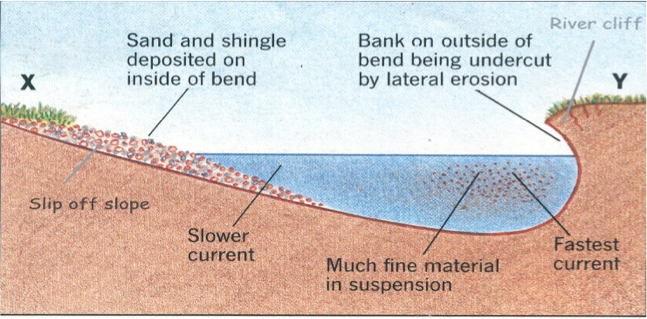
Meander – A large bend in a river caused by lateral erosion (through hydraulic action and abrasion). The water on the outside of the bend travels fastest (thalweg) and erodes away to form a river cliff (mainly HA and Abrasion). The water on the inside of the bend travels slowest and deposits material to form a river beach.
Oxbow Lake – A Horseshoe ShapeLake
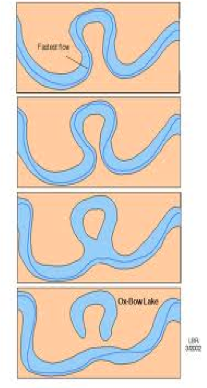
- The outside of the meanders have the quickest water (thalweg) and are eroded by hydraulic action and abrasion.
- The outside of the meanders move closer together narrowing the ‘neck’ in between.
- Eventually (usually during a flood) the river cuts straight across the neck following the quickest route
- After this the river slows down by the old bend and deposits material cutting off a oxbow lake
Lower Course
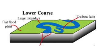
- Flat gradient
- Very wide river channel
- Little energy
- Little erosion (lateral)
- Slower
- Very small load
- Very wide valley
In the Lower Course of a river the most common features are floodplains and levees.
Floodplain – A flat area surrounding the river for water to spill on to.
The river erodes laterally (sideways) not vertically.
The river valley is widened creating a large flat area.
When the river overflows (floods) material is deposited as the water loses energy.
Over time the sediment builds up in layers creating a floodplain.
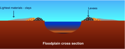
Levee – Raised banks along the river.
- What is a levee, explain its formation.
- Your answer should include: Raised / Banks / Floodpain / Embankments
- What processes happen most at each course?
- Your answer should include: Upper / Middle / Lower / Erosion / Transport / Deposition
- Describe how a river changes as you journey down the long profile.
- Your answer should include: Source / Mouth / Deeper / Wider / Shallow / Processes